Overview
Images and information about
15 morphotypes of cyanobacteria ("blue-green algae")
collected from orange algal mats in Canada Stream,
McMurdo
Dry Valleys
- View images to assist identification.
- Browse taxon information such as length, width, description, and references.
- View individual algae counts from the same sample site to estimate year-to-year variability.
This web site is part of an ongoing larger effort to study the interactions between hydrologic, chemical and biological processes in controlling aquatic ecosystem dynamics of the McMurdo Dry Valleys.
Please visit our "companion" site: Antarctic Freshwater Diatoms and our related sites: Diatoms of the United States and Rocky Mountain Lake Algae.
What are cyanobacteria?
Contact Us
Data & related studies
This website is based on a dataset of more than 60 images and a dozen samples. Four sample sites on Canada Stream were sampled in three different years.
A broader study using these data showed that substantial yearly changes in cyanobacterial mat composition were not related to stream flow variations. In contrast, the types of diatoms present have been shown to be affected by stream flow. These differences imply that changes in cyanobacterial mat composition have little to no effect on the relationship between diatoms and stream flow. For details see the link to a PDF report at the top of the References page.
Citation
Any publications that use data obtained from this web site should, when possible, cite the original publications listed with the data. Otherwise, use the following:
Mora, M., McKnight, D., Lubinski, D.J.,. Antarctic Cyanobacteria web site: Taxa and samples from the Dry Valleys. McMurdo Dry Valleys LTER, visited at http://culter.colorado.edu/cyanobacteria


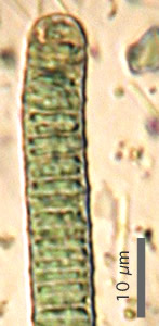
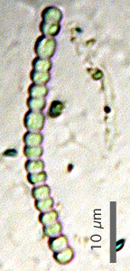
Oscillatoria irrugua (D) and Nostoc spp. , two of the 15 morphotypes.

Antarctica. Location of McMurdo Station and the Dry Valleys.
Image: NASA Goddard Scientific Visualization Studio/ K. Jezek.

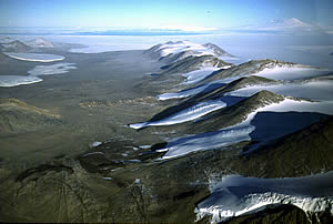
Taylor Valley. View to the east through one of the Dry Valleys. The Kukri Hills dominate the right side of the picture. McMurdo Sound and Mt. Erebus (uppermost right) are visible in the background. Near the coast and extending into the valley is Commonwealth Glacier (upper left), with Lake Fryxell bracketed between Commonwealth and Canada glaciers. Photo: Mike Prentice, UNH, VALMAP GIS web site.
